-40%
Kernville, Calif gold mine LOCATIONS, old RARE 1st ed report, BIG sep. maps, VG+
$ 65.87
- Description
- Size Guide
Description
Rare 1940 1st-ed. mining report has allgold
mines in Kernville quadrangle, Calif.
Area's rich gold deposits and unique geology are described;
report also has 42 pages on famous Big Blue gold mines
T
his rare first-edition report describes and maps the unique geology and mines of the Kernville quadrangle in Tulare, Inyo and Kern counties, California.
Small detail of oversize foldout map from report shows location of Dead River placer in relation to Isabella. Pay gravel was said to average 50 cents a yard (1940 prices).
This beautiful area includes the Sierra Nevada high country and the Kern River.
And I'm not exagerrating about this being "rare." I haven't listed one in six years.
Yes, those mineral resources include rich gold deposits: "Gold is the most widely distributed and by far the most important metal . . . in this area," says page 323.
The book covers big and small prospects alike, but devotes the most pages (42) to the geology and mining operations at the famous Big Blue group of mines, near Kernville — which produced several million dollars in ore in just its early years, from 1860 to 1883. (And remember gold was only selling for .53 an ounce in 1860.)
Many mines are OPEN to prospecting
And many of these mines are on forest service or public land and COMPLETELY open to exploring and prospecting. They are MILES from any population center, so there's no one to bother you no matter what you do (we are NOT condoning anything illegal). No fences, no no-trespassing signs, no barking dogs.
Gold nuggs, dust and ore await!!
Get out your picks and shovels or metal detectors or even a camera (beautiful pictures here abound!) and get to work. Some of these mines were BIG ones. It is EXTREMELY
doubtful
that old-time miners got all the good stuff. It is EXTREMELY
likely
that much gold and silver is still waiting to be extracted by some guy who decided to dig when everyone else sits around, drinks beer and says, "It can't be done."
Strike it rich!!
It can be done! You've watched the COMPLETE idiots on the Gold Rush Alaska TV show finally strike it rich. There is no need to travel to Alaska when HUGE riches could be waiting in middle California.
Although some of the smaller mines may only rate a brief mention in the text, they are pinpointed on the report's large foldout map (see detail above for example). Also, almost all of the mine locations are given in
infallible range-and-township coordinates
. Just plug 'em into your GPS or look 'em up on the appropriate topo, and you're there!
Shaded area on this map shows Kernville quadrangle (over 1,000 square miles) in relation to Kernville, the small settlement of Little Lake (in Inyo County, north of Ridgecrest), Mt. Whitney, Owens Lake and the Kern River. The famous Inyo County mines of Darwin and Cerro Gordo are just off the map to the right (east) of Owens Lake.
Covers 1,000
square miles
This is not some gift-shop rockhound book; it was written about miners for
miners by miners. Prepared by the California Division of Mines, it's a treasure trove of information for history buffs, bottle collectors, photographers, geologists, hikers, offroaders, rockhounds, stock certificate collectors, prospectors — just about anyone interested in learning about or exploring the geology and old mine sites in the historic Kernville quadrangle. To see just how much real estate these articles cover (over 1,000 square miles), see the map at left and the "where is it?" section toward the end of this ad.
Three separate articles
The articles about Kernville-quadrangle gold mines and geology are part of a larger 173-page periodical —
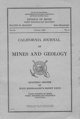
California Journal of Mines and Geology, Vol. 36, No. 4, October 1940
. The articles are: "Mineral Resources of the Kernville Quadrangle," 12 pages; "Descriptive Geology of the Kernville Quadrangle, California," 34 pages, plus large foldout geology map (detail at top); and "Geology of the Big Blue Group of Mines, Kernville, California," 42 pages, including oversize foldout map of the mines' geology.
No collection of Kern County, Kernville or California mining memorabilia is complete without this hard-to-find report — packed with geologic information, ore value, mine production stats, history, even claim holders' names and addresses.
Platy foliation in schists of the Kernville series produce strange formations like this one, in photo from report.
This report is considered primary source material; much of this info is available
nowhere else
. It is a first edition, totally out of print, with no official reprints available, in overall very good to excellent condition. So bid now or forever hold your peace. Once it's gone, it's gone.
Also a valuable tool for stock certificate collectors
Because this report also lists mine owners and different names for the same mine, it is also a valuable tool for collectors of stock certificates. Some mine descriptions contain brief histories of the mines in question (including dates of actual production) and previous owners.
Mines described
Here are a few of the 22 gold mines described in the text:
Beauregard Mine
, adjoining the Big Blue on the west; the pay shoot is reported to be 600 feet in length, averaging three feet in width.
Brown Dyke mine
, situated at the head of Gold Canyon, about one mile south of Fairview and 16 miles north of Kernville (book has exact range-and-township coordinates for this and all the other mines). Owner is F. Albert Morrison of Fairview.
Commonwealth mine
, 32.4 acres, on the west side of the Kern River, about three miles north of Kernville.
Iconoclast Mine
, on Erskine Creek, eight miles southeast of Bodfish.
Laurel mine
, consisting of six claims. The formations are quartz monzonite, crystalline limestone and schist.
Million Stamp mine
, 10 claims and two fractions. A mill was built at the portal of the main tunnel. Idle except for assessment work..
Satica property
, owned by Michael and Robert Satica of Susanville, California.
View of the mill at the Big Blue mine as it appeared in 1940.
The report also contains locations and data for mines other than gold mines: antimony, copper and tungsten (seven mines).
Big Blue gold mines were richest in area
As previously mentioned, the largest section in this particular report is about the history, operation and geology of the famous Big Blue group of mines, about 1.5 miles north of Kernville, the richest mines in the Kernville quadrangle. The Big Blue group got its start in 1860 when Lovely Rogers was looking for his lost mule. Not only did he find the mule but also a rich outcrop. The resulting boom led to the rise of Quartzburg and Kernville. Because of all the fighting and disorderly behavior in Quartzburg, the saloon section of the town was moved 1.5 miles south to the present site of Kernville, which flourished as Quartzburg fell into ruins.
From 1860 until 1883, the Big Blue mines produced several million dollars in ore. From 1883 to 1936, the mines were operated with little success. That changed dramatically in 1936–'40, when the mines began consistently producing "commercially profitable ore." In 1940, there were three working shafts — the Big Blue, Lady Belle and Beauregard, but the text thoroughly details shafts and adits used all the way back in the early days of the mines in the 1800s. Partially responsible for the mines' renewed success were new milling methods, which could effectively harvest both the free gold in the ore and the gold locked up in sulphides.
Small detail of map from report shows underground workings at Big Blue Mines.
Geology of Big Blue mines and Kernville quadrangle
Obviously, because this is a geology report after all, there is no lack of information on the interesting geology of the Big Blue mines and the quadrangle as a whole.
The quadrangle consists of a great central platform, about 7,000 feet high. The major structural feature is the Kern Canyon fault. Two minor faults are also
mentioned. Metamorphic rocks of the area belong to the Kernville series, of probable Carboniferous age, composed chiefly of quartzites, phyllites, schists and marbles, which occur as huge inclusions in the plutonic rocks that have invaded them. The relationships, structure, mode of occurrence and age are discussed.
As for the Big Blue mines, the description of the intrusive rocks shows the close relationship existing between the alaskite, aplite, silexite and primary blue quartz of the ore. The expulsion of the mineral-bearing carriers which produced the ore was brought about by the various processes of hydrothermal activity. The mineralizing solutions deposited their burden within the shear zone as ore shoots and in the fractures and seams in the hanging wall.
Where is Kernville quadrangle?
The Kernville quadrangle covers the southeastern corner of Tulare County, part of southern Inyo County and a portion of northeastern Kern County. The center of the quad is about 50 miles northeast of Bakersfield and includes a large part of the majestic southern Sierra Nevada, mainly the areas adjacent to the valleys of the Main Fork and the South Fork of the Kern River.
Kern County, in south-central California, is the next county north of Los Angeles and Orange counties and the third largest in the state. Adjacent counties are Inyo, Tulare, Kings, San Luis Obispo, Santa Barbara, Ventura and San Bernardino.
Filled with RICH deposits
Not only is Kern County itself filled with some of the state's richest mineral deposits, major historical supply routes also crisscrossed the county to other rich gold and silver strikes in more remote areas to the east and north, including mines at Cerro Gordo, Bodie, Darwin, and mines in Inyo County's Death Valley and Panamint Valley areas. Even the early 20th century boomtowns of Tonopah, Rhyolite (Bullfrog) and Goldfield (much farther north in Nevada) had supplies originate from — or cross — Kern County.
Towns and cities in Kern County include: Arvin, Bakersfield, Bear, Valley Springs, Boron, Buttonwillow, Caliente, California City, Cantil, Delano, Di Giorgio, Edison, Edwards, Fellows, Frazier Park, Glennville, Gorman, Greenacres, Johannesburg, Keene, Kernville, Lake Isabella, Lamont, Lebec, Lost Hills, Maricopa, McFarland, McKittrick, Mettler, Mountain Mesa, North Edwards, Onyx Pond, Pumpkin Center, Coalinga, Shafter, Taft, Tehachapi, Tupman, Wasco, Weldon, Wofford, Heights and Woody.
The report:
The Kernville quadrangle gold mines and geology articles are part
of a larger 173-page report, the one for sale here —
California Journal of Mines and Geology, Vol. 36, No. 4, October 1940
(cover at right). The articles are: "Mineral Resources of the Kernville Quadrangle," 12 pages; "Descriptive Geology of the Kernville Quadrangle, California," 34 pages, plus large foldout geology map (detail at top); and "Geology of the Big Blue Group of Mines, Kernville, California," 42 pages, including oversize foldout map of the mines' geology. Published by State of California, Department of Natural Resources, San Francisco, six by nine inches.
Overall in very good to near-fine shape with some slight yellowing, bumped corners; some slight edge staining on front cover and some pages (hardly worth mentioning). Couple stamps on cover. Binding is tight. Maps are folded into text and attached at binding. Both are in very good, near-fine shape. No wear tears along map folds. All in all, one of the best copies that I have seen of this report.
Payment methods and domestic shipping
Free priority mail shipping in the U.S. Paypal only, per ebay rules. I pride myself on bulletproof packaging and ship in sturdy cardboard boxes or reinforced padded envelopes. Yes, I have slightly raised my prices after USPS prices have gone through the roof.
The fine print:
Feel free to contact me if you have any questions about the item or terms of sale.
Do not
wait until you have bought the item to ask if it includes three free gallons of gas (it doesn't).
I post feedback once a week. Not responsible for typographikal errors.
Good luck and thanks for looking!
